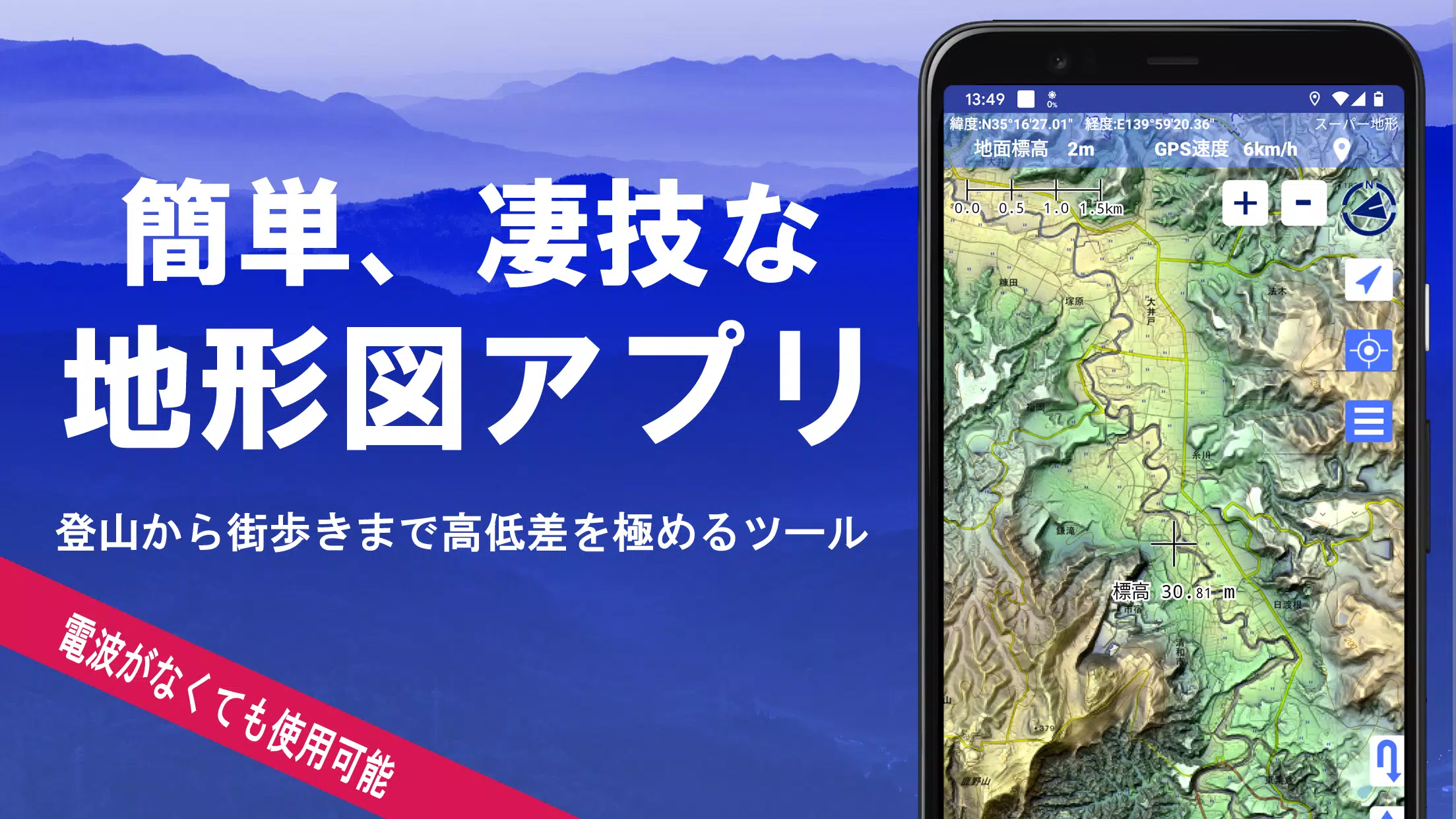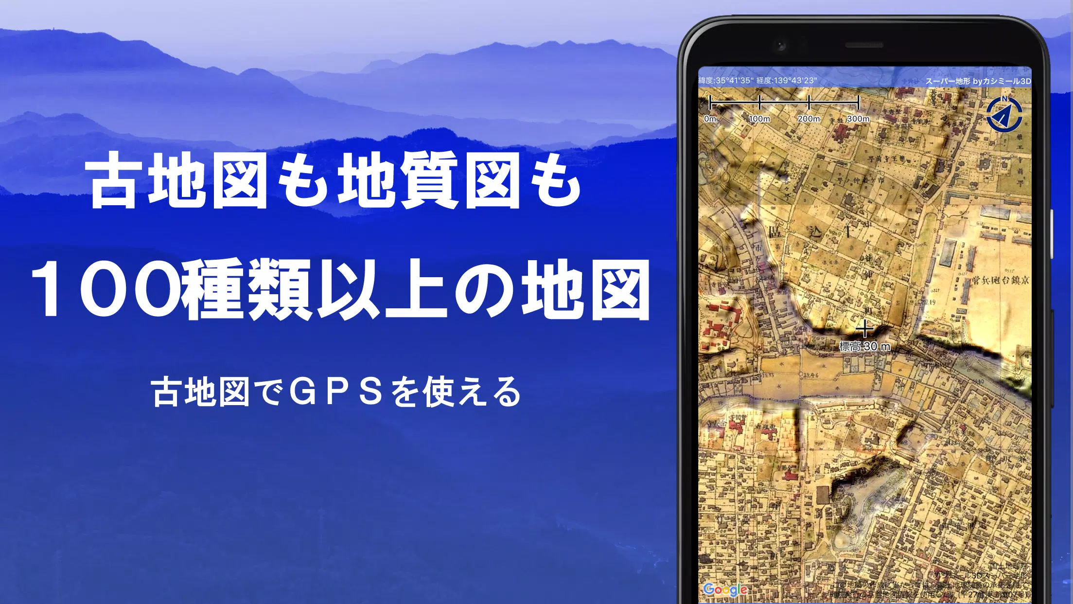
Explore over 100 types of maps, including the renowned Geographical Survey Institute map, designed to optimize your experience from mountain climbing to casual strolls through the city. These maps are crafted to leverage the terrain's height differences, providing a comprehensive tool for all your adventures.
In 2018, this remarkable application received the Japan Cartographic Society Award for Best Work, underscoring its excellence and utility in the field of cartography.
- Utilize "super terrain data" that enhances terrain visualization through unique technology.
- Access maps from the Geospatial Information Authority of Japan, including topographic, geological, historical, and prewar Ordnance Survey Department maps.
- Record your tracks (trajectories) with the GPS function, featuring GPX log input/output and editing capabilities.
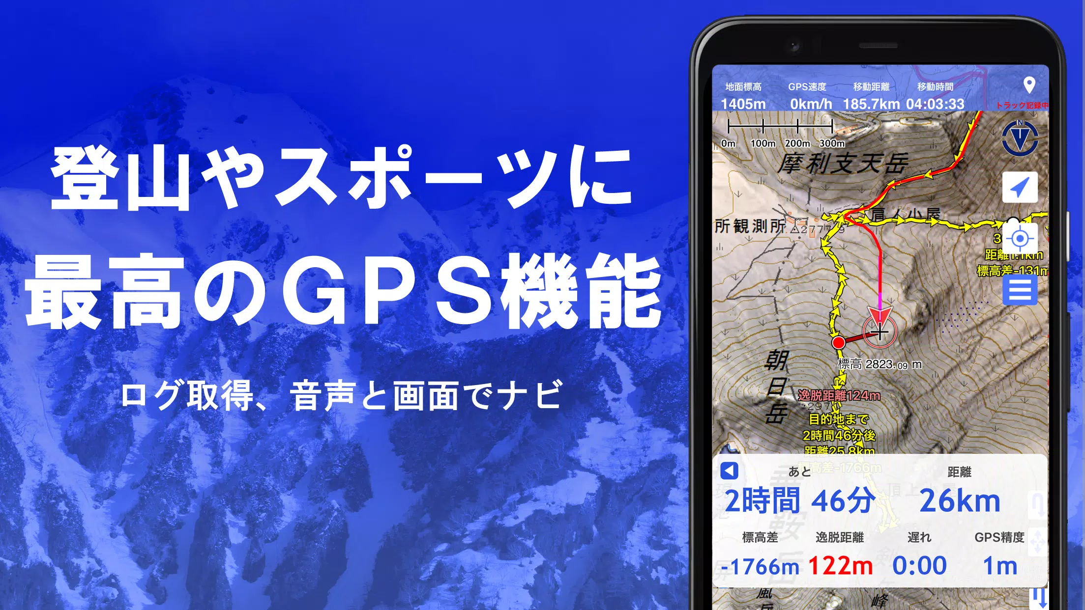
- Benefit from features tailored for urban walks, mountain climbing, and other outdoor activities, including GPS navigation with audio cues and comprehensive data recording and editing.
- Employ a visibility determination function for creating cross-sectional diagrams, aiding in observation and radio communications, with options to display buildings.
- Experience a 360° panoramic view function that identifies mountains by name and displays the sun, moon, and GPS points.
- Enjoy offline capabilities with the GPS function, bulk map download, and map cache features, ideal for areas without radio signals.
- Link photos to specific points for enhanced memory and documentation.
- View contour lines generated from elevation data for a clearer understanding of the terrain.
- Display the Military Grid Reference System (MGRS) grid (UTM grid) for precise location referencing.
- Read, display, and edit GIS data from GeoJSON files, and draw custom shapes.
- Use the application overseas for global adventures.
- Print maps or output them as PDFs for detailed planning and record-keeping.
- Enjoy a dark theme for better visibility in various lighting conditions.
A Wealth of Maps at Your Fingertips
Choose from over 100 types of maps, including our exclusive super topographic data and maps from the Geospatial Information Authority of Japan. Note that availability of aerial photographs may vary by age group, with "latest" and "around 1974" offering broader coverage. Enjoy free access to maps using super terrain data for 5 days after app installation.
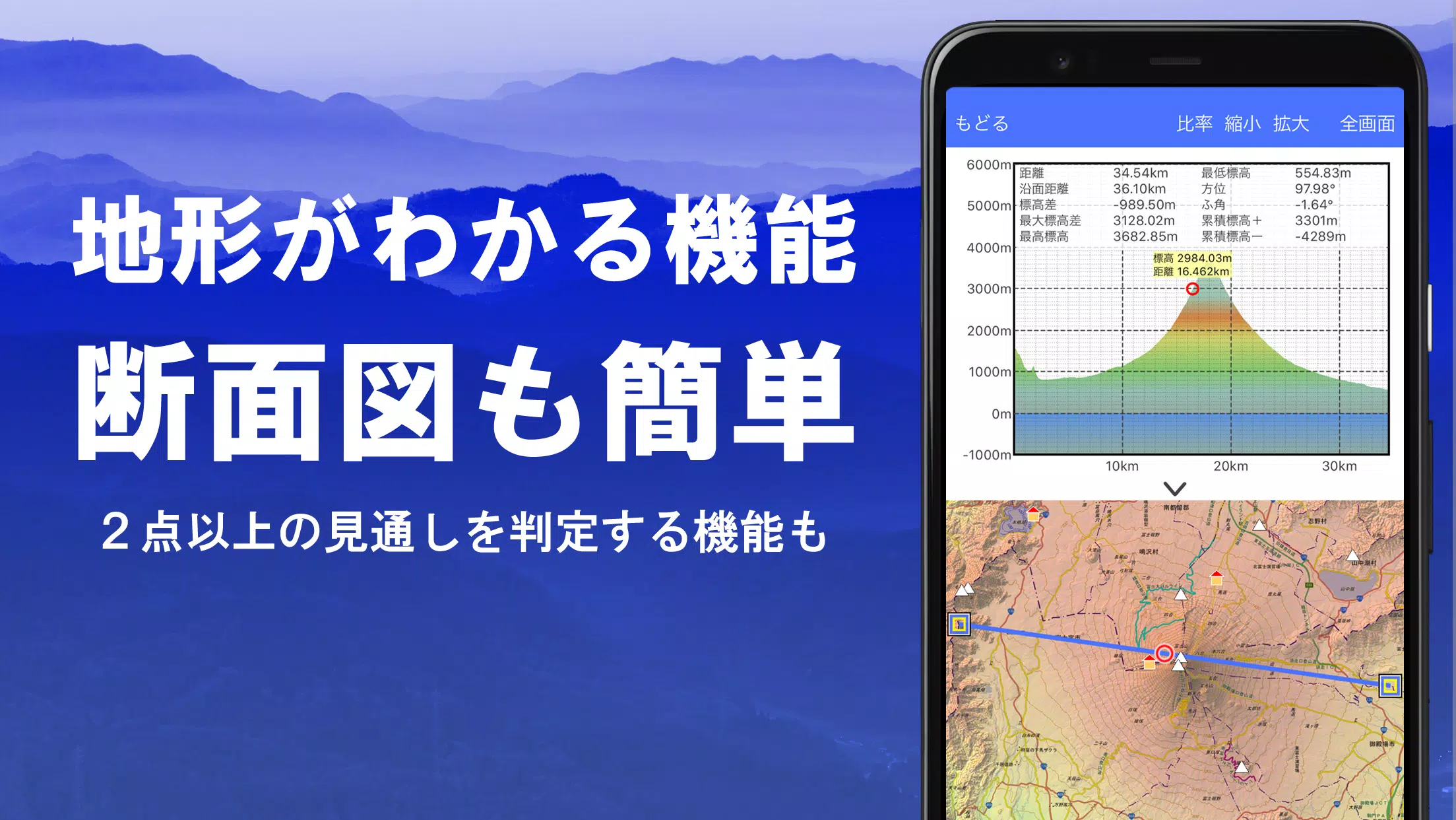
Creating Cross Sections and Outlooks
Effortlessly draw cross sections at any map point. The app includes a visibility judgment function, accounting for Earth's curvature and atmospheric differences, ideal for route planning during climbs, assessing wireless visibility, and understanding terrain. Where available, PLATEAU building data can be integrated into your cross-sectional views.
Elevation Palette Function
Customize your map's background color using the elevation palette function, adjusting the gradient in 1cm increments to suit your preferences.
Panoramic View
Access panoramic observation maps that reveal mountain names from any location on the map. A 360-degree panorama syncs with your smartphone's compass, aiding in mountain identification. Display the sun and moon, including moon phases, to explore phenomena like Diamond Fuji and Pearl Fuji. View GPS points and enjoy panoramic views of mountains abroad.
GPS Function
Leverage your smartphone's GPS to acquire location data and record tracks. The app supports high-precision positioning suitable for serious mountain climbing and outdoor activities. Graphically display recorded tracks with parameters such as elevation gain, speed, time, and elapsed time. Receive voice and alarm notifications as you approach designated points, view photos linked to specific locations, and send map center positions to NaviCon.
GPS Track Summary Playback
Replay your track logs in full, with the app automatically matching and displaying photos taken at corresponding times. Icons at photo locations allow for easy access and viewing.
GPS Navigation Function
Navigate along preset tracks with the Track Navi function, using your smartphone's GPS. Alerts sound if you deviate from the track, preventing you from getting lost. Additionally, utilize route navigation for urban exploration and point navigation for reaching specific locations.
GPS Data Editing Function
Manage GPS-related points, routes, and tracks, organizing them into folders and viewing them in a user-friendly tree format. Create tracks directly on the map and import/export in GPX format for seamless integration with mountain climbing sites.
Map Usage Outside the Service Area (Offline)
Continue using maps in areas without signals, such as during mountain climbs. The bulk download function ensures you have all necessary scale maps for your specified area, with clear visibility of what is being downloaded. A cache function further enhances offline usability.
Map History Function
The app remembers your previously viewed locations, allowing you to return easily.
Custom Map Compatibility
Import and utilize custom maps created with Kashmir 3D's map cutter, including your own or scanned maps. When using the map cutter, divide each image into approximately 256 x 256 pixels and send the resulting kmz file to Super Terrain via email or Cloud Drive.
GeoJSON Compatibility
Display and edit points, linestrings, and polygons from GeoJSON files, and draw new shapes to customize your maps further.
Print/PDF Output
Print any map area at a specified scale or create PDFs for detailed planning and record-keeping.
Cooperation with Other Apps
Input and output GPS data in GPX, KML, and GDB formats, facilitating data exchange with other apps, the PC software "Kashmir 3D," and trajectory data from mountain climbing sites.
Backup Function
Backup all app data (excluding cached maps) and remove it from your smartphone. Restore data even if you delete the app or encounter device issues. An automatic backup feature using Google Drive ensures your data remains up-to-date. Refer to the manual for detailed instructions.
About the Billing Function
Certain functions, such as maps using super terrain data, GPS track functions, and cross-sectional views, require in-app purchases. After payment, the number of search results for place name searches increases.
- Fees: Annual payment of 780 yen/year.
- Free Trial: Enjoy a 5-day free trial upon first installing the app. After 5 days, some features and maps will no longer be available unless you make a purchase. You will not be charged without a purchase action.
- Confirmation and Cancellation: Check or cancel automatic updates through Google Play by navigating to "Regular Purchase" and selecting "Super Terrain."
- Price Revision: Prices may change due to future feature enhancements. Early purchase can be advantageous.
Terms of Use
The copyright holder and developer are not responsible for the outcomes of using this application. When starting GPS for the first time, you will be prompted to allow location services. Be aware that continuous GPS use can drain your battery, and if your device is used for emergency communication, consider carrying a spare battery. For detailed navigation instructions, refer to the PDF at https://www.kashmir3d.com/online/superdemapp/superdem_navi.pdf. Note that on some smartphones, track recording may be interrupted due to power-saving features; turning off the screen may help, but it's not a permanent solution.
Tags : Maps & Navigation